

In a foreword, Infrastructure Minister Dr Michelle Haywood said: ‘Flooding and coastal erosion are not distant threats. They are present realities that have shaped our island’s past and will continue to challenge our future.’
The document covers the period 2026-2036.
It identifies areas of river flooding, surface water flooding, coastal flooding and coastal erosion now and in the future and sets out an action plan for the next 10 years.

.jpeg?width=209&height=140&crop=209:145,smart&quality=75)
.jpeg?width=209&height=140&crop=209:145,smart&quality=75)

Since the last strategy in 2016, £2.8m has been invested in tidal flood defences in Castletown, protecting 90 properties from harbour flooding, and £7m has been invested in river defences and flood mitigation works in Laxey, protecting 64 properties, with more works programmed.
Some £2m has been spent on in defences in Douglas, protecting 49 properties and critical national infrastructure.
There are 341 properties currently at risk from coastal flooding but this is expected to increase by nearly four times, to 1,279, with the effects of climate change over the next 100 years, the strategy report notes.
The areas at most risk of flooding from the sea are Ramsey, Douglas, Castletown and Peel.
Some 12% of properties, and a similar proportion of the highways network, are in areas identified as at risk of surface water flooding. Around 4,810 are currently at risk, this figure estimated to t rise to 9,820 over the next century.
It is estimated that economic damages from surface water flooding over a 100-year appraisal period could reach £2.8bn, if no action is taken.
Around 793 properties are currently at risk of river flooding, the number estimated to reach 1,042 by the year 2126.
Outlining the economic case for flood and coastal risk management, the report says that based on the number of properties at risk, significant economic impacts are expected, and these impacts are likely to exceed funding available for mitigation.
Understanding the level of investment that may be required over the next 100 years is essential for developing a strategic approach, it adds.
An action area plan has been developed.
Proposals within the 15 areas identified are attributed to five categories of flood and coastal erosion risk management work, and have been assigned short, medium or long-term timescales.
Short-term is action achievable within the next two years, while medium-term would be in the lifetime of the 10-year strategy and long-term timescales are more than 10 years.
Areas highlighted at risk but not classified as ‘action areas’ are noted as hotspots in the strategy documents.
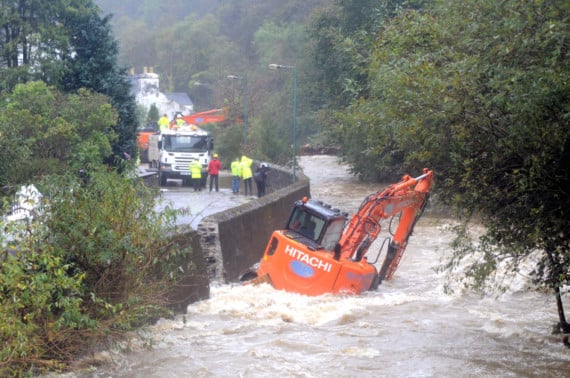
Significant changes in responsibilities for flood and coastal risk management have taken place following the accepted recommendations of the independent review of the devastating Laxey floods in October 2019.
The flood management division of the Department of Infrastructure was formed in 2020.
Implementation of the new 10-year strategy will be overseen by the Flood Management Coordinating Committee, formed of representatives from across government, and chaired by the DoI.