
The island is expected to face significant travel disruption this weekend as gale force winds, linked to the remnants of hurricanes Humberto and Imelda, move in from the Atlantic.
Although no formal weather warnings had been issued by Ronaldsway Met Office by midweek, forecaster Colin Gartshore confirmed that one is likely to be in place.
The bad weather is forecast to begin on Friday afternoon, with gusts reaching up to 70mph in exposed areas along with periods of heavy rain.
Saturday is also expected to be affected, with gusts of up to 60mph accompanied by showers, before conditions gradually ease into Sunday morning.

.jpeg?width=209&height=140&crop=209:145,smart&quality=75)
.jpeg?width=209&height=140&crop=209:145,smart&quality=75)
Mr Gartshore said: ‘There are going to be gale to severe gale force winds at times starting on Friday and going through until Sunday morning. But it is not all that unusual for autumn.
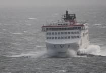
‘It is likely to cause travel disruption, and it is likely some ferry services will be cancelled. It could also affect flights as well.
‘The weather is not looking as bad as we thought it was on Tuesday. There is likely to be a weather warning in place, but it is probably going to be yellow when we had been set to issue a more severe amber warning.
‘There is also some more rain coming in which will be heavy going into Friday afternoon.’
The Isle of Man Steam Packet Company has already announced schedule changes in anticipation of the conditions. On Thursday, the Manxman sailing to Heysham will depart half an hour earlier than scheduled, leaving at 7.30am. The return journey will also be brought forward by 30 minutes, leaving Heysham at 1.15pm.
The unsettled weather is being driven by the remnants of hurricanes Humberto and Imelda, which have been edging east across the Atlantic. Both systems caused disruption on the east coast of the United States, particularly in Florida and North Carolina, and have also affected Bermuda.
Mr Gartshore said it was uncertain whether the conditions would be severe enough to trigger the first named storm of the UK season.
He explained that while gusts could be strong enough to cause problems for travel and coastal areas, the overall system was weakening as it moved further east.
Despite this, ferry sailings and flights remain at risk of disruption, particularly through Friday evening and Saturday. Islanders planning to travel are advised to check updates from the Steam Packet and airlines before setting out.
Conditions are expected to improve gradually from Sunday, with winds easing and temperatures turning milder into the start of next week.
Mr Gartshore added that autumn weather systems of this kind are not unusual, but the combination of strong winds, heavy rain and the possibility of travel disruption makes this weekend’s forecast one to watch closely.