

The Met Office has issued two yellow weather warnings.
One is for coastal topping.
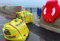
Strong to gale force southerly winds are due to affect the island tomorrow, leading to some coastal overtopping of waves with a risk of debris on exposed coastal roads and promenades around the time of high tide (1.14pm).
Areas to be affected include Shore Road Rushen, Castletown, Laxey and Ramsey Promenades, as well as central and northern parts of Douglas Promenade.


The other is for heavy rain.
Rain will affect the island for much of the day tomorrow, falling heavy at times through the morning, with 10-15mm of rainfall expected across the island but a risk of 20-30mm over higher ground. This may lead to areas of standing water along roads and possibly some localised flooding.
The heavier bursts will clear by midday, though the rain will continue into the afternoon, becoming lighter and patchier.
What does yellow weather warning mean?
Yellow‘Be Aware’ - Risk of bad weather affecting activities. Some travel delays, risk of minor damage, localised or temporary disruption.
The forecast
Rain this morning, with some heavy bursts, and giving a risk of localised flooding.
During the afternoon the rain will become lighter and patchier, but at the same winds will increase strong to gale force from the south or southwest.
Then through the evening the last of the rain will clear, as winds swing southwest and ease a little. Maximum temperature 12 Celsius.
Tonight will see brisk winds and only a small chance of a shower, with tomorrow then quite windy again, with strong to gale force westerly winds, sunny intervals and scattered showers.
Sunrise: 8:34am Today
Sunset: 4:18pm Today
Outlook
Showers on Thursday, with possibly a longer spell of rain for a time. Lighter winds initially, but these increasing through the day.
Comments
This article has no comments yet. Be the first to leave a comment.