

The weather forecast from the Met Office at Ronaldsway Airport.
There is a yellow weather warning in place for coastal overtopping around high tide, 3pm, this afternoon.
Areas at risk include central and northern ends of Douglas promenade, Castletown promenade, Shore Road, Rushen (Gansey) and to a lesser extent Laxey promenade and Ramsey promenade.
Today will be cloudy with spells of rain continuing to affect the island, turning heavy at times.
 Met Office give verdict on whether the Isle of Man will have a white Christmas
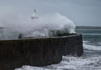 Storm Bram brought one of the island’s strongest gusts in a decade, forecasters say
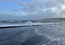 Fresh warning for coastal overtopping to come while cleanup from Storm Bram continues
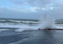 Storm Bram: Met Office issue fresh weather alert for storm-force winds
Quite windy with a strong south to southwest wind, which will turn to the northwest later this afternoon. Top temperature around 10°C.
The rain will turn to sleet or snow later this evening, before clearing to hail and snow showers overnight, as the strong to near gale force wind turns to the north or northwest.
Turning cold overnight with temperatures falling close to freezing, giving a risk of ice.
Outlook
A mixture of bright or sunny spells and blustery wintry showers tomorrow, which may become more frequent and heavy for a time around middle of the day, before gradually dying out towards evening.
Temperatures only reaching up to 6°C at best, and feeling much colder in the strong west to north-westerly wind.
After a cold and frosty start with a risk of ice, Wednesday will start dry with some early brightness, before the cloud thickens to bring outbreaks of rain around lunchtime, falling as sleet or snow over higher ground initially.
The winds will settle to the south or southeast and start to freshen, as it turns milder with temperatures reaching up to 9°C during the evening.
Sunrise: 6:39am
Sunset: 6:18pm
Comments
This article has no comments yet. Be the first to leave a comment.