


The Met Office has issued a yellow warning for tonight.
Weather forecasters say there will be snow/ice and severe gales.
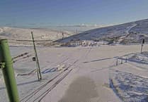
The forecast:
Heavy rain will soon move in from the west this evening, falling as snow over the hills for a time at first.

.jpeg?width=209&height=140&crop=209:145,smart&quality=75)
.jpeg?width=209&height=140&crop=209:145,smart&quality=75)
The rain will clear to wintry showers during the early hours of tomorrow morning, as the southerly wind quickly turns to the west and becomes gale to severe gale force for a few hours, giving gusts of 60-70mph. Minimum temperatures falling generally near to 3°C later tonight, but close to freezing over the hills with a risk of ice.
Wintry showers will continue to affect the island at first tomorrow, particularly for the north of the island, but these will become more isolated during the morning as some bright and sunny spells develop. A fresh to strong westerly wind making it feel cold with temperatures only reaching up to 6°C at best.
Friday will be bright with sunny intervals, although one or two passing wintry showers are still possible. Highest temperature near to 5°C, but feeling much colder than that in the strong westerly wind.
Comments
This article has no comments yet. Be the first to leave a comment.