

.jpeg?width=752&height=500&crop=752:500)
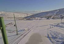
A weather warning for snow has been issued with wintry showers heading to the island.
The 18-hour yellow warning - meaning ‘be prepared’ - has been issued by Ronaldsway Met Office which begins at 6pm today (Thursday) and will remain in place until midday on Friday.
The island has been hit by rain and hail already but the showers are set to turn wintry on higher ground later on Thursday.
In the early hours of Friday, colder air will arrive which means wintry showers are set to hit lower ground - particularly in the south of the island.


.jpeg?width=209&height=140&crop=209:145,smart&quality=75)
Forecaster Stuart Davison said: ‘Showers on Friday are falling as rain to low-levels and sleet for high ground but will be replaced by a larger area of showery rain through this evening and to start the overnight period. This rain will be falling as sleet and snow for high ground with any snow confined to above 800 feet.
‘Towards the end of the overnight period (from around 5am) colder air allows the snow level to lower, but at the same time the precipitation starts to peter out with wintry showers returning.
‘These showers will start to become confined to the south of the island on Friday morning but will fall as a mixture of rain, sleet or hail to low-levels and as snow/hail above 300 feet.
‘Slight accumulations of snow are possible above 800 feet overnight and then Friday morning accumulations are also possible above 300 feet in areas affected by the wintry showers – most likely in the south of the island. Any accumulations of hail to low-levels will be short-lived but may cause some isolated icy patches.’
Comments
This article has no comments yet. Be the first to leave a comment.