This week, Dave Martin of the Isle of Man Natural History and Antiquarian Society looks at a group of structures which potentially saved thousands of lives during the Second World War. Undamaged by enemy action, they are now at risk from government inaction.
The Isle of Man’s sea-girt location has been a significant factor for millennia - both as a highway and hindrance for trade, and also a defence in times of conflict.
Mann’s long coastline, especially the northern coast from Michael to Ramsey, has made it vulnerable to sea-borne landings, probably most famously in the Battle of Sky Hill - so most-times, the military coastal emphasis was on defending the Island itself.
The island has also though long been seen as a location from which to exert power around the Irish Sea.
.jpg?width=209&height=140&crop=209:145,smart&quality=75)


.jpeg?width=209&height=140&crop=209:145,smart&quality=75)
The island served as a base for Vikings and Viking rule and in the 18th century Royal Navy and Revenue cutters sought to interdict free trade from Mann to adjacent islands which the neighbouring administrations felt led to loss of Customs import duties.
Until the 20th century, defence focussed on protecting the island, either as a power base, or in case it became a power base.
Structures associated with this were the castles and harbour works, and over the centuries, defensive works have made their mark on the Manx landscape, from promontory forts to gun batteries to defend the Island’s harbours.
In terms of contributing to wider defence of the realm and military adventures, from the ’days of sail and musket’, Manxmen had served - principally at sea - voluntarily or having been plucked by the press gang. In both world wars, this continued with Manx men and women volunteering or being called-up to the defence of the British Realm - either in the armed services or other supporting roles.
During the 20th century though, as the benefits of an offshore location were appreciated by the UK government, the island played a bigger part in the defence of Britain, initially as a convenient place to corral internees.
In the First World War, the principal visual impact of this was the building of the temporary internment camp at Knockaloe. After the Great War, the massive camp was thoroughly cleared and most, but not all, of the wooden buildings left the island (see Buildings at Risk in Isle of Examiner of September 25, 2018).
In the inter-war years, it became clear that air power would not just be exerted over the trenches and battlefields, but also used to project power much further field - be that over sea lines of communication, or attacking targets well beyond the front lines.
For those who would see them, the clouds of war building over Europe were visible even from the Isle of Man for several years prior to the outbreak of the Second World War.
Anti-aircraft defence was a major concern, and two visible aspects were the establishment in 1938 of a Territorial Association (later the Manx Regiment), and civil engineering works to prepare aerodromes at Jurby and Andreas.
It was realised that effective defence against air attack needed maximum notice of incoming raids, and it was not sufficient to rely on observers seeing/hearing them when they crossed the coast.
It had been noticed that radio reception suffered interference when aircraft were flying nearby, so in February 1935, a bomber flew around a powerful BBC transmitter near Daventry to see whether a Post Office receiver would pick up a signal reflected from the aircraft. It did, and funds were immediately made available to develop it further.
Second World War
Following Mr Chamberlain’s announcement on September 3, 1939, holidaymakers left the island, to be replaced by foreign nationals who were unfortunate enough to be in Britain when war was declared and who were regarded as potential enemies to be rounded up en-masse and once again corralled on the Isle of Man - but rather than in a hutted camp, they were confined in camps mostly using existing guest- or other houses.
There were no major building projects associated with Second World War internment, but the iconic barbed-wire fences on the promenades were visible to all - their footprints still survive in a few places on promenades, most have gone and the few remaining are under threat from roadway replacement.
By 1940, right around the coast of Britain and the Isle of Man, a series of aircraft radio detection sites had been developed featuring tall metal and wooden masts along with groups of camouflaged concrete bunkers.
The concept of sending radio signals to bounce off moving aircraft to receive the reflected signal was now reaching increased levels of sophistication. By carefully interpreting the return signals it was possible to calculate the range of the aircraft from the transmitter, its speed of flight and its direction.
This combined ability inspired the acronym RADAR, derived from RAdio Detection And Ranging.
Looking at a map of the British Isles produced in the early 1940s there were over 120 of these radar sites around the United Kingdom forming a chain of detection.
In fact, the whole system was known as Chain Home.
Theoretically it was impossible for an enemy plane to approach the British coast without being picked up on the radar screens, and this information was centrally processed in the UK to allow air raid warning sirens to be sounded and for fighter planes to be scrambled to intercept the enemy.
On the Isle of Man four of these stations were built, one at Bride, one at Scarlett, one at Dalby and a later specialist system at Cregneash known as Chain Home Low which could detect low-flying aircraft which the other stations couldn’t. We will return to Chain Home Low and Radar/Radio training in another article.
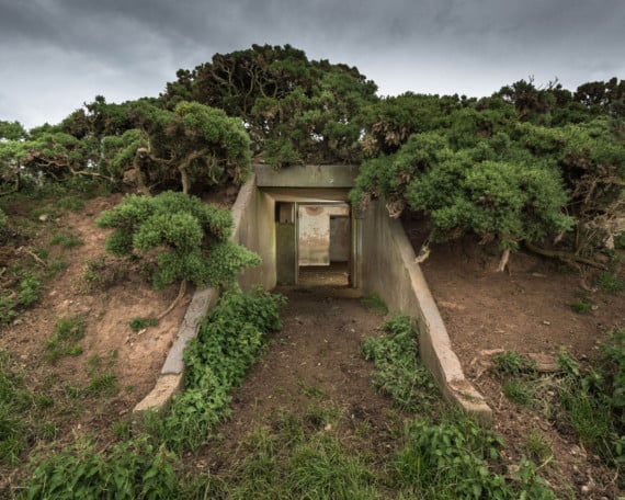
The three Chain Home sites had similar distinctive buildings - camouflaged bunkers, brick built with reinforced concrete roofs.
In these the operators sent and received the radio signals, interpreting the results on cathode ray tubes and goniometers.
Nearby, assistants plotted the information onto Ordnance Survey maps and forwarded it by telephone up the network which consolidated it, starting with the ops room in the newly-built west wing of Ramsey Grammar School.
In the fields nearby there were steel transmitting radio masts reaching up to 335ft and wooden receiving masts reaching up to 240ft.
In addition there were a number of smaller structures such as guard houses, electrical sub-stations, air raid shelters and, on each site, a massive bunker housing diesel generators.
These were the standby set buildings which could provide almost instant power back-up in case the mains supply faltered or failed.
Near to the technical buildings there were the buildings that housed the men and women that operated the equipment, day and night.
At Bride, for example, there were some 120 personnel involved including supervisors, radar operators, mechanics, officers, clerks, equipment assistants, motor transport and mechanics, cooks, butchers and stewards, telephonists and nursing orderlies as well as service police and gunners.
All these for just one of the stations. At Dalby they were billeted in Glen Maye but at Bride and Scarlett they were housed in camps on requisitioned farmland.
The importance of the work carried out in these bunkers around the UK and on the island cannot be overstated.
This remarkable early warning system will have saved countless lives.
It couldn’t stop the bombers coming, but it could give warning of their approach, up to an hour in advance. This not only allowed defensive fighters to be scrambled, but also crucially allowed the sirens to be sounded in UK cities to alert civilians and give them time to get into air raid shelters.
The island’s stations will have offered advanced warning for bombing raids on Belfast, on Glasgow, and on the North West of England.
The extraordinary thing is that the Chain Home stations on the island, particularly the assemblage at Bride, are now regarded as the most complete set of buildings still extant, 70 years after they were abandoned.
Throughout the UK there are odd bunkers, mast bases, the occasional air raid shelter associated with this system, but nothing like what remains on the Isle of Man.
The great tragedy is that our remains are not protected.
The bunkers spread across the fields north of Bride are still in remarkable condition.
Some of them even have original equipment in them.
However, they are under threat. They stand on land which is subject to planning permission granted to Island Aggregates to extract sand and gravel all around and beneath them.
One of the bunkers has already been buried by the government in one of the nearby landfill sites, and the remaining bunkers are gradually being isolated by the gravel extraction.
The current policy of Island Aggregates is to excavate around the bunkers and to leave them untouched. Its current chief executive officer recognises the value of the structures, even if the government doesn’t.
However, he is under no obligation to retain them and there is always the danger that future management, or indeed a new operator, may change the policy (there would be nothing to stop them doing this) and remove them and utilise the material underneath.
Already the great concrete blocks that tethered the masts to the ground have been dug up and left exposed, and some of the smaller ancillary buildings have been bulldozed and the site is no longer the coherent radar station it once was.
How has this been allowed to happen?
Planning permission was given to Island Aggregates for this extraction, but it is clear the then planning committee had, or were given, no sense of the importance of this site.
In fact, the island has a number of Second World War remains which are almost all unprotected.
Whereas in Jersey such structures are protected and form part of an important heritage trail for locals and tourists alike, here on the island this vital island contribution to the preservation of democracy in the western world is free to be demolished.
A request in 2015 to have the structures registered remains outstanding, even though they are the best preserved example of the world’s first functioning radar system in the British Isles and will have played their part in saving countless civilian lives.
Their social and historical significance is immeasurable.
It would cost noting to register these structures, no money is required for their maintenance and their registration wouldn’t interfere with Island Aggregates’ business.
But what registration would do is ensure their future survival.
They are every bit as important as our ancient hill and promontory forts and surely deserve the same protection and respect.
Comments
This article has no comments yet. Be the first to leave a comment.