


The island is set for a brief respite from persistent wind and rain - but it will come with freezing temperatures.
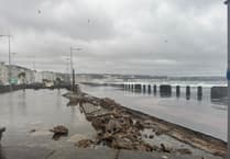
Last week, a series of weather warnings for strong winds and coastal overtopping were issued as gusts battered the Isle of Man, leading to damage along Douglas Promenade and minor flooding in Ramsey.
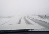
Even on quieter days, conditions have remained damp and overcast, with spells of fog, rain and blustery winds.
However, forecasters say things will change on Friday and Saturday, bringing drier conditions alongside a cold snap and sub-zero temperatures.
.png?width=209&height=140&crop=209:145,smart&quality=75)
The colder spell is likely to prompt further weather warnings for frost and ice, and there is a chance of snow on higher ground. Lows on Friday and Saturday could fall to -1C, with daytime highs of just 5C or 6C.
Ronaldsway Met Office forecaster David Britton said: ‘The rain and wind will clear overnight into Friday but with that will come colder air.
‘It will largely be dry but there will be a risk of frost and ice, particularly on Saturday morning. There will not be much precipitation, which means the risk of snow will be low, but there could be some on higher ground which could affect the Mountain Road.’
The Met Office is expected to issue further warnings in the coming days relating to frost and icy conditions, particularly during the early mornings on Friday and Saturday.
The cold snap is not expected to last, with wind, rain and milder conditions forecast to return on Sunday.
Mr Britton added: ‘It will only be Friday and Saturday that will be dry as unsettled weather arrives from the Atlantic into Sunday.
‘By Monday it looks like we will have quite strong winds and frequent showers once more. It looks like this unsettled weather is going to stay for a bit longer yet.’