


The island is feeling the effects of Storm Ciara.
This morning’s Steam Packet and its return has been cancelled.
Every sailing until Monday evening’s is under threat, the ferry company says.
The Met Office has issued weather warnings.
 Met Office give verdict on whether the Isle of Man will have a white Christmas
 Manxman turns back to island during Heysham journey due to medical emergency
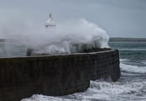 Storm Bram brought one of the island’s strongest gusts in a decade, forecasters say
 Tonight's Steam Packet sailings cancelled due to 'adverse weather'
There is a yellow warning is for severe gales today.
An amber warming has been issued for coastal overtopping and minor inner harbour flooding Sat night / Sun morning
The forecast:
Much of today will be dry and bright with some sunshine, before spells of heavy rain start to affect the island from around dusk this evening. Top temperature around 8°C. The strong to near gale force south to southwest wind will increase to gale or severe gale force this afternoon giving gusts of 55 to 65 mph quite widely across the island, but up to 70 mph in more exposed spots.
Staying very windy tonight with the rain often turning heavy and creating standing water on the islands roads with a risk of localised flooding. Some coastal overtopping is also expected for exposed locations around the time of high tide tonight (~11pm). Minimum temperature near to 4°C.
The heavy rain at first tomorrow will gradually clear by late morning, leaving scattered blustery showers, as the gale to severe gale force south to southwest wind becomes a westerly gale as the rain clears. Significant coastal overtopping will once again occur around the time of high tide (~11:20am), with temperatures peaking at 10 or 11°C during the morning, before falling by a few degrees into the afternoon and feeling much colder in the wind.
A mixture of bright or sunny spells and scattered showers on Monday, falling as hail or sleet at lower levels but as sleet or snow over the hilltops. The showers will move through very quickly on the strong to gale force westerly wind, which will make it feel cold with highs of only 6°C.
Comments
This article has no comments yet. Be the first to leave a comment.