
The Department of Infrastructure has applied for planning permission for two new flood defence projects in Laxey.
The first application [21/00298/B] consists of proposals to construct a continuous flood protection wall along the bank of the river to the rear of the properties along Glen Road.
As noted in the DoI’s planning application statement, 51 of the 62 homes flooded during the major incident in October 2019 were located on Glen Road.
The walls will be of the same height as the existing Manx stone walls, but will be made out of a combination of reinforced concrete and natural cladding.

-(2).jpeg?width=209&height=140&crop=209:145,smart&quality=75)

.jpg?width=209&height=140&crop=209:145,smart&quality=75)
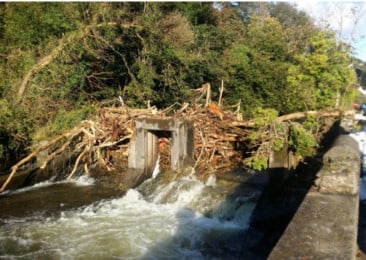
The DoI’s second planning application [21/00300/B] involves demolishing the concrete substructure of an existing weir which had fallen into disrepair.
This will also involve the regrading of the river channel and replacing the old structure with a ’rock ramp’ (made up of rows of boulders) in order to better control the river’s flow.
During the October floods, debris built up behind the existing weir structure which the DoI said ’along with other factors’ had contributed to the water overtopping of the highway wall adjacent to Glen Road.
Following the floods of 2019, the superstructure of the weir was removed to prevent any such future blockages, and these proposals would entail the removal of the remaining weir sub-structure this summer.
The lower part of the existing weir is also in a visibly poor condition, with protruding steer reinforcing bars and a hole on the side which has been scoured by water.
This structure is also proposed to be removed and replaced with another ’rock ramp’ of boulders.
In justifying the overall need for these new defences, the DoI statement concludes: ’Flood risk is significant and likely to get worse due to climate change, so the surrounding area and adjacent properties are all at risk of significant harm or damage if nothing is done’.
The DoI described the scheme as being ’an important scheme for the residents of Laxey, protecting properties for the future against flooding, repairing dilapidation and securing the residential viability of the area’ whilst also ’protecting the visual amenity of the conservation area using sympathetic design.’
Comments
This article has no comments yet. Be the first to leave a comment.