

We’ve had a drier than usual start to spring this March.
According to the Ronaldsway Met Office, March rainfall amounted to 47.5mm, compared with the long-term mean of 63mm.
The second week of the month was the wettest, with two thirds of the month’s rain between March 8 and 14.
Temperatures were mixed with a cold start to the month and a warmer back end, but not the record-breaking temperatures felt in south east England.


We ended up with a mean temperature of 7.4°C - half a degree above the March mean of 6.9°C.
The warmest day was the last of the month, March 31, when we reached a maximum of 14.7°C.
There were 113.5 hours of bright sunshine, only slightly below normal.
Despite the lengthening days, the most sunshine was recorded on the first of the month, 9.5 hours.
Gales were recorded on two days and strong winds on 13 days, giving a mean wind speed of 16.0mph, compared to the March mean of 15.2mph.
The highest gusts of 54mph were measured on March 10 and 11.
There were two days with hail but no sleet, snow or thunderstorms.
Fog was observed close to the airport on two days during the month.
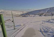
The settled spell we have enjoyed is coming to an end with much colder air coming down from the north this week.
This will bring showers which could be wintry at times with hail and sleet, especially on higher ground.
Maximum temperatures reach 7 or 8° but will feel chilly.
Comments
This article has no comments yet. Be the first to leave a comment.