
The Isle of Man Met Office has upgraded its weather warning for Storm Dave to amber, with forecasters warning of potentially damaging winds across the island on Saturday evening.
The latest alert, issued at 12pm on Saturday, is valid from 6pm on Saturday until 3am on Sunday.
Forecasters say south or south-west winds are likely to produce gusts of between 60 and 70mph across the island, with a risk of gusts of 70 to 80mph in exposed areas.
The Met Office said conditions could bring down trees and branches and carry a small risk of structural damage to buildings.
.jpeg?width=209&height=140&crop=209:145,smart&quality=75)

Winds are expected to begin easing towards midnight and into the early hours of Sunday morning.
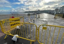
The warning also highlights the risk of large waves affecting coastal areas during the night’s high tide at around 2am.
Although winds are forecast to be decreasing by that point, the large tide combined with strong winds could see significant waves breaking over exposed coastal areas, particularly in the south of the island.
Parts of promenades, including the northern end of Douglas Promenade, could also be affected, with debris likely to be left behind by the waves.
The Met Office said major harbour or quayside flooding is not expected, although some of the most vulnerable locations could see minor water ingress for a short time.
Areas near the River Sulby in Ramsey may see some water, while flood defences in Castletown are expected to be deployed as a precaution.
Forecasters say the situation will continue to be monitored closely and the warning will be updated if conditions change.
Storm Dave is expected to bring the strongest winds during Saturday evening before conditions gradually improve overnight and into Sunday morning.