

When in spring 2016 Heritage Great Britain – owner of such UK attractions as The Needles in the Isle of Wight, Land’s End in Cornwall and John o’Groats in Scotland – bought Port Soderick and said it wanted to ‘bring the site back to life’, hopes, as well as eyebrows, were raised.
Perhaps something resembling the old Victorian and Edwardian resort would emerge, or a revamp of the old cafe and restaurant enjoyed by holidaymakers in the 1960s and 70s?
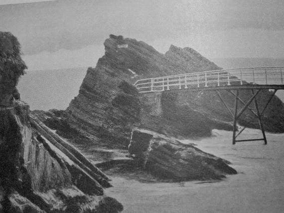
However, within a year the site was sold on to the private company Ballacregga Estate Ltd, which has since submitted plans for a boat house and four private houses. The only public part of the scheme is permitted access to the beach and former promenade – and not the long-derelict elevated walkways enjoyed around the base of the cliffs by the Edwardian visitors. They once took the holidaymakers to imaginatively named and marketed caves, rock outcrops and bathing coves, but, more recently, have been the preserve only of determined anglers willing to risk slipping behind the barricades to reach vantage points on the rocks beyond. Now the pub and cafe building has been demolished, as have the walkways.
Similar elevated walkways in the cliffs also once existed at the end of the Groudle Glen Railway, to allow Victorian visitors to access the rocky coves housing its ‘zoo attractions’ of sealions, polar bears and brown bears – one element of the past that, of course, no-one would advocate bringing back today. However, old postcards show lines of visitors looking down at the animals from a high bridge across one of the cliff chasms and some rusting supports and steps can be seen around the revived glen railway’s Sealion Rocks terminus.
.jpeg?width=209&height=140&crop=209:145,smart&quality=75)


.jpeg?width=209&height=140&crop=209:145,smart&quality=75)
Port St Mary still has a somewhat tamer elevated metal and concrete walkway curving around the shoreline to connect Chapel Bay beach and the Underway, but this can still be dramatic at high tide, with the waves surging beneath your feet and crashing against the rocks of the shore. Not far away, some of the cliff paths between Port Erin and Bradda, and the wooden bridges across clefts in the cliffs, have latterly been fighting a losing battle with erosion.
While the Isle of Man seems to be losing elements of its old tourism infrastructure, there has been the revival of long-closed cliff walkway and caverns path across the water in Northern Ireland.
The Gobbins footpath (a name derived from the same Gaelic word meaning ‘bird’s beak’ or ‘headland’ as Gob-y-Deigan – ‘Devil’s Point’, between Peel and Kirk Michael, and Gob Lhiack – ‘Point of the Slates or Flat Stones’ – just south of Port Soderick) was the vision of the railway engineer Berkeley Deane Wise, who woke up to the tourism potential of cliff scenery when he was involved in building a new line around Bray Head, near Dublin, in the mid-1870s.
Wise found that the railway company had also opened a dramatic high cliff path which tourists, brought from the city by the railway at weekends, were willing to pay a fee to walk along and admire the views.
He put this lesson into practice in the 1880s when he moved to Ulster and became engineer for the Belfast and Northern Counties Railway, building lines in County Antrim. The northern coast was already a famous tourist spot because of the extraordinary hexagonal basalt pillars of the Giant’s Causeway.
Wise saw a way that his railway company could cash in on tourism.
It was the development of Larne harbour that led Wise to develop a new resort town at Whitehead, near the mouth of Belfast Lough. Sand was even shipped down from Portrush to create a new beach.
Wise then set about creating a new scenic cliff path running from Whitehead promenade to the dramatic viewpoint of Blackhead, which had views across the North Channel to the Mull of Kintyre and mountains of south-west Scotland.
But it was on the peninsula known as Islandmagee, across the lough from Larne, that in 1902 he built an even more spectacular cliff path with iron bridges and elevated walkways that may well have inspired the ones which appeared at Port Soderick after around 1906.
The new Gobbins path hugged dramatic basalt cliff-faces, crossed steel footbridges over chasms into which the waves of the North Channel surged below, and went in and out of tunnels and caves cutting into the rock. It also used the steps of old smugglers’ paths and guide books told visitors romantic tales about this aspect of the area’s past.
Tourists, having been brought from Whitehead railway station by wagonette, entered the Gobbins path through a hole in the rocks named ‘Wise’s Eye’, where they payed a fee or showed an inclusive railway ticket. This entrance was only open from 10am to 5pm daily in summer and was sealed off with a gate at other times. Two footbridges then took the path across chasms to the small inlet of Sandy Cove, which, guarded by a sea stack, was an exciting place to have a picnic, with deck chairs provided and tea served from a hut nearby.
A real highlight was the unique Tubular Bridge, made up of circular steel rings holding up the narrow bridge deck and leading to an isolated sea-stack called the Man O’War, because from some angles it resembled an old sailing ship (Port Soderick had its own iron bridge leading to a sea-stack called Dragon Rock which appears on old postcards).
A section of the Gobbins path 30ft above the sea was called The Gallery, where the path had to be projected out from the sheer cliff-face on metal brackets. A stretch called The Aquarium allowed tourists to look down into a pool in the rocks, while The Tunnel was likened by some to a dark dungeon and Spleenwort Cave was popular with fern hunters, then something of a craze.
The path culminated in a suspension bridge dubbed The Swinging Bridge, because it was possible for mischievous youths to shake it when tourists were crossing. The path ended suddenly at a steep drop called Gordon’s Leap but there are indications that Wise planned to extend it for a further three miles.
Unfortunately his health declined before that could happen and then, thanks to new motor road competition and then the partition of Ireland, the finances of the railway company gave out.
In the Depression years there was no extra manpower to maintain the Gobbins path and, after it was closed during the Second World War, it quickly fell into disrepair, reopening only for a few years during the 1950s under the management of the new Ulster Transport Authority. However, it was still visited from time to time by adventurous types and those who remembered its thrilling scenery dreamed of it one day reopening, despite the difficult environment created by the Troubles from the 1970s onwards. In particular, the County Down photographer, film-maker, historian and lecturer John H Lennon worked hard to promote the idea of reviving the path. With the dawn of a more peaceful Northern Ireland after the Good Friday Agreement, the Army and Navy even offered to help. Although John H Lennon did not live to see his dream realised, he did live long enough to hear that Larne Borough Council was embarking on a detailed project of restoration.
In 2011 the council put together a funding package comprising money from its ratepayers, a cross-border EU project helping schemes in Northern Ireland and neighbouring parts of Eire and western Scotland, and support from Ulster Garden Village Ltd charitable fund. The reinvented path, which some of bridges reconstructed, including the unique tubular bridge, reopened in 2014, as was a new visitor centre telling the story of how the path was built, outlining some of the stories and legends of the area.
While Edwardian visitors seem to have been unfazed by the idea of tackling the Gobbins path in their best suits or long dresses and wearing broad-brimmed hats and boaters, today’s visitors must pre-book for a guided tour on which they must wear hard hats and sensible footwear and which they are strictly warned not to embark on if they suffer from certain health conditions.
The revived Gobbins path has suffered setbacks due to storm damage and rock falls but it promises to be fully open again next spring.
Comments
This article has no comments yet. Be the first to leave a comment.