

The Met Office has issued two yellow weather warnings.
There could be icy patches until about 9am.
Then from 9am till 4pm, sleet and hill snow will hit give accumulations of an inch or more above around 800ft, this will slowly thaw tomorrow evening as it becomes milder ahead of rain tomorrow night.
The forecast:
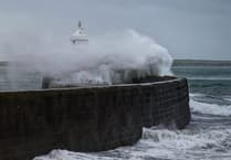 Storm Bram brought one of the island’s strongest gusts in a decade, forecasters say
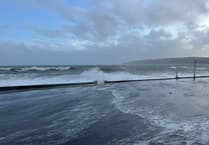 Fresh warning for coastal overtopping to come while cleanup from Storm Bram continues
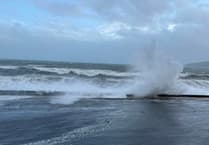 Storm Bram: Met Office issue fresh weather alert for storm-force winds
 Four Steam Packet sailings cancelled as Storm Bram brings gale force winds
Dry at first today but soon turning cloudy with outbreaks of rain and sleet developing from mid-morning, turning to snow over the hills, giving some accumulations above around 800 feet, before clearing around mid-afternoon. The strong west to southwest wind will turn to the southeast and fall light for a time, with highs of 5°C.
A further area of rain will arrive later this evening, continuing overnight and bringing milder conditions as temperatures gradually rise, as the southwest wind increases becoming strong to gale force.
Wet tomorrow with outbreaks of rain which maybe heavy at times around midday, before clearing to wintry showers into the afternoon. Another windy day with the westerly gales increasing to severe gales during the evening. Top temperature around 11°C at first, but falling to 5 or 6°C later in the day as it turns colder.
Showers at first on Monday will soon die away becoming mostly dry with some bright or sunny spells, before a band of rain arrives overnight. The gale to severe gale force west to northwest wind will moderate during the day with highest temperature around 9°C.
Comments
This article has no comments yet. Be the first to leave a comment.