

The Met Office has issued an amber weather warning for snow tomorrow.
It is valid from noon.
Snow is likely to become persistent across the island by Thursday afternoon, often heavy, and continuing through the evening and into the early hours of Friday.
Significant moderate, perhaps locally heavy, accumulations of snow are possible at all levels and this will be accompanied by strong to near-gale force east to northeast winds leading to blizzards and drifting, especially but not exclusively on high ground and in the west of the island.
 easyJet plane forced to fly back to Liverpool despite landing at Isle of Man Airport
-(2).jpeg?width=209&height=140&crop=209:145,smart&quality=75) Yellow weather warning as torrential rain expected this weekend
Yellow weather warning as torrential rain expected this weekend Two trees felled after safety inspections found they posed ‘immediate risk’
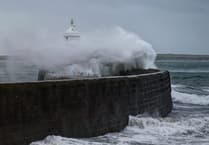 Storm Bram brought one of the island’s strongest gusts in a decade, forecasters say
Cable icing could also be an issue for overhead conductors in some locations.
It has also issued a yellow weather warning for snow, ice and coastal overtopping. That is valid until 2pm tomorrow.
Throughout the period temperatures will remain below ZERO above around 1000 ft, leading to the risk of icy patches.
From 7pm tonight temperatures away from the immediate east coast will also subject to icy patches, although many surfaces dry.
Isolated snow/hail showers through this evening and overnight with negligible accumulations increasing the risk of icy patches wherever they occur.
During Thursday morning an approaching frontal system is expected to lead to occasional outbreaks of mainly light snow that may fall as sleet along the immediate east coast. Slight accumulations of snow possible away from the east coast. This will also be accompanied by a strong easterly wind.
The strong easterly winds are expected to lead to minor coastal overtopping around exposed coasts and promenades around the time of the Thursday high tide (around 12:30pm). Areas at risk include the whole of Douglas promenade, Laxey prom, Ramsey prom, Derbyhaven and to a lesser extent Castletown prom and Shore Road Rushen (often called Gansey).
There's a high risk of disruption to travel and, perhaps, for network services (power and communications).
Comments
This article has no comments yet. Be the first to leave a comment.