


The weather forecast from the Met Office:
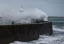 Storm Bram brought one of the island’s strongest gusts in a decade, forecasters say
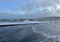 Fresh warning for coastal overtopping to come while cleanup from Storm Bram continues
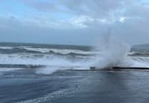 Storm Bram: Met Office issue fresh weather alert for storm-force winds
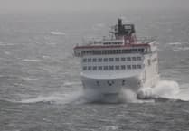 Four Steam Packet sailings cancelled as Storm Bram brings gale force winds
Cloudy with rain arriving towards dawn, often turning heavy this morning and perhaps turning to sleet or wet snow briefly over the hilltops before readily turning back to rain.
The rain will clear later this afternoon leaving a dry but cloudy and misty end to the day. Breezy with a fresh to strong south-easterly wind, which will turn to the south or southwest this afternoon with highs of 9°C.
Heavy rain will return later this evening and tonight creating standing water on the islands roads, before gradually clearing towards dawn tomorrow morning. A windy night with the southerly wind turning to the west or southwest and becoming strong to near gale force. Minimum temperature near to 2°C.
Tomorrow will start dry and bright, but will soon turn fairly cloudy as showers spread across the island, becoming heavy and prolonged at times and falling at sleet or snow over the hills, and a mix of rain, sleet or hail at lower levels. A very windy day with the west to south-westerly wind increasing to severe gale force, giving gusts quite widely of 50-60 mph but up to 65 mph in more exposed spots. Maximum temperature around 7°C.
Still very windy at first on Sunday with a gale to severe gale force west to southwest wind, which will slowly ease during the day, otherwise it will be bright with sunny spells and just the small chance of one or two passing wintry showers. Highest temperature only around 7°C, and feeling much colder in the wind.
Comments
This article has no comments yet. Be the first to leave a comment.