


The Met Office has issued another yellow weather warning for ice and wintry showers.
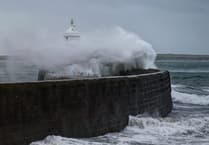 Storm Bram brought one of the island’s strongest gusts in a decade, forecasters say
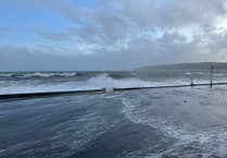 Fresh warning for coastal overtopping to come while cleanup from Storm Bram continues
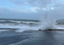 Storm Bram: Met Office issue fresh weather alert for storm-force winds
 Four Steam Packet sailings cancelled as Storm Bram brings gale force winds
The forecast:
A cold start with a few wintry showers and the risk of ice, particularly over higher ground or in places where recent showers have left some slight and temporary accumulations. The showers will become more isolated this morning, as the strong and gusty northwest wind gradually falls light into the afternoon; highs of 6°C.
Mostly dry this evening and tonight with some clear spells and light winds, as temperatures dip close to freezing with a widespread risk of ice, before temperatures start to recover slightly later in the night as the wind settles to the south or southwest and starts to freshen.
Tomorrow will be windy with the southerly wind increasing strong to gale force during the morning, as rain arrives from the west by mid-morning, turning heavy at times before clearing to showers towards dusk. Top temperature around 8 or possibly 9°C.
Bright with some sunny spells on Friday, but also one or two passing wintry showers, moving through fairly quickly on the fresh to strong west to northwest wind. Highest temperature only around 6°C. Then turning cloudy with outbreaks of rain developing overnight.
Comments
This article has no comments yet. Be the first to leave a comment.