


The Met Office has issued a yellow weather warning for ice this evening.
A band of rain will clear to the south later this evening, bringing much colder conditions across the island tonight as clear intervals develop, allowing road surface temperatures to fall close to or slightly below freezing.
The roads most at risk are those above around 800ft, where there is a risk of ice forming on untreated surfaces which remain damp or wet from this evening’s rain.
The forecast:
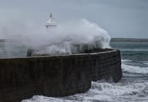 Storm Bram brought one of the island’s strongest gusts in a decade, forecasters say
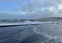 Fresh warning for coastal overtopping to come while cleanup from Storm Bram continues
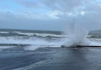 Storm Bram: Met Office issue fresh weather alert for storm-force winds
 Four Steam Packet sailings cancelled as Storm Bram brings gale force winds
A clear start and a mostly bright morning with some sunshine and only isolated wintry showers but it will turn rather cloudy into the afternoon before the wintry showers become more frequent later, giving slight accumulations of hail or snow mainly over higher ground. Temperatures only 5 or 6 Celsius at best, and feeling even colder in the strengthening northwesterly wind.
Wintry showers tonight and tomorrow morning, becoming more isolated during the afternoon as the fresh or strong northwest winds fall lighter; top temperature around 7°C.
Becoming windy by Thursday morning with a spell of rain, heavy at times, but clearing in the afternoon. Temperatures reaching 8 or 9°C.
Comments
This article has no comments yet. Be the first to leave a comment.