

-(1).jpeg?width=752&height=500&crop=752:500)
A weather warning for wind and rain has been issued with travel disruption and localised flooding expected as Storm Chandra sweeps in.
Now, Ronaldsway Met Office has issued a yellow warning – meaning be aware - as gusts of up to 65mph are expected. Heavy rain will also come in which could see flooding while there could be snow on higher ground which could close the Mountain Road.
The warning, in place from 3am to midday on Tuesday, says: ‘A rapidly deepening area of low pressure to the south of Ireland (Storm Chandra) will allow winds to increase in the Isle of Man to severe gale force overnight into Tuesday and peak before dawn, then easing late morning.


‘East or southeast winds will mean 40-45mph with gusts widely 55-65mph. This will lead to disruption to travel as well as a risk of some damage due to fallen trees, etc.
‘Areas of patchy rain arrive on Monday afternoon and evening will become persistent and sometimes heavy on Tuesday morning with rainfall accumulations of 10-20mm widely with 20-40mm over high ground. This may lead to surface water flooding in prone locations.
‘Between 3am and 9am the rain may turn to sleet or snow over high ground. This may lead to disruption on, for example, the A18 Mountain Road. The sleet or snow then turning back to rain late morning on Tuesday.
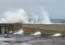
‘There is a risk of minor coastal overtopping along exposed coasts and promenades around the time of high tide (5am).’
Forecaster Stuart Davison further explained the reasons for the weather warning.
He said: ‘The worst of the weather is going to be overnight on Monday and through to late morning on Tuesday.
‘The UK Met Office has just named Storm Chandra which has already prompted an amber weather warning for Northern Ireland.
‘We are likely to see gusts of 55-65mph. We have various weather issues with heavy rain likely to cause localised flooding.
‘The rain may turn to snow on higher ground which means we could see the Mountain Road closed overnight while there could also be coastal overtopping.’
There have been weather warnings issued for a week now, mainly due to coastal overtopping.
Mr Davison explained: ‘While there have been strong winds, the main issue last week was down to the high spring tides rather than particularly strong winds.
‘It looks like we may get a respite from the strong winds on Wednesday but, then, on Thursday and Friday they will increase once more but they will not be as strong.’