


The Met Office has issued two yellow weather warnings.
 Storm Bram brought one of the island’s strongest gusts in a decade, forecasters say
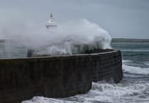
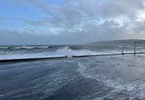 Fresh warning for coastal overtopping to come while cleanup from Storm Bram continues
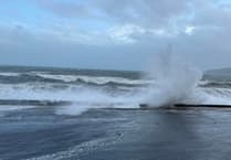 Storm Bram: Met Office issue fresh weather alert for storm-force winds
 Four Steam Packet sailings cancelled as Storm Bram brings gale force winds
One is for gales and coastal overtopping. The second is for snow and ice.
The forecast:
Turning cold with temperatures lowering leading to the risk of ice formation on higher routes, but otherwise dry and bright with a strong southwest wind this morning. The winds will then increase to severe gale force early this afternoon with gusts 60-65mph, and 70mph in more exposed spots. Snow showers in the afternoon may allow blizzard conditions over high ground for a time. Coastal overtopping around high tide (2:30pm).
Still cold on Sunday with gale force winds at first, easing to become strong for the afternoon. Mainly dry with just the odd isolated wintry shower. Top temperature 7°C but with significant wind chill.
Tending to be cloudy on Monday with some isolated wintry showers, fresh westerly winds and temperatures of 7°C.
Comments
This article has no comments yet. Be the first to leave a comment.